Historic State Map - Oklahoma Indian Territory - Roeser 1879 - 23 x 28.53 - Vintage Wall Art
Product information for Historic State Map - Oklahoma Indian Territory - Roeser 1879 - 23 x 28.53 - Vintage Wall Art
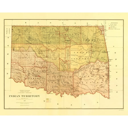
Old State Map - Oklahoma Indian Territory - Roeser 1879 - This is an exquisite full-color Reproduction printed on high-quality gloss paper art paper or canvas. Print Size: 23.00 x 28.53 inches 58.42 X 72.46cm Sites and Townships Specific To This Map Are: Fort McCullock Fort Washita Fort Holmes and Claremore. The following towns are featured: Indian Territories located within the state of Oklahoma. Territories are separated by color and boundary line. Some landmarks of interest include the Shawnee Hills Coal Creek Rock Creek Copper Creek Choates Creek Brush Creek Canadian River and the Arkansas and Pennsylvania Railroad. This Map is Situated in: State of Oklahoma (OK) United States. SKU: OKZZ0015 Original Maps are often difficult to find and usually have fold lines identifying stamps or markings tears ragged edges and assorted other natural signs of age that detract from their beauty. All of our maps have been professionally restored to depict their original beauty while keeping all historical data intact. These maps are fabulous pieces of history full of information useful to Historians Genealogists Cartographers Relic Hunters & Others. They make fascinating conversation pieces and splendid works of art for the home or office.


